|
The Calgary and Edmonton Trail (C & E Trail)
Revised May
2022
Photo descriptions
and credits at bottom of page.
 What eventually became known as the Calgary and Edmonton Trail
(C&E Trail) was
developed along a relatively ancient natural north-south glacial corridor
several kilometres wide on the western margin of
parkland located between the dense forest to the west and the hilly land
to the east. It is likely that a large number of people migrated to
North America from Asia using this corridor during the latter part
of the last glacial period 14,000 years ago and continued their migration
southward (although there is evidence that the earliest people were
on the continent prior to the last ice age possibly from along the
west coast, across the Pacific or Atlantic oceans or an ice corridor
prior to the last glacial period that started about 25,000 years
ago). What eventually became known as the Calgary and Edmonton Trail
(C&E Trail) was
developed along a relatively ancient natural north-south glacial corridor
several kilometres wide on the western margin of
parkland located between the dense forest to the west and the hilly land
to the east. It is likely that a large number of people migrated to
North America from Asia using this corridor during the latter part
of the last glacial period 14,000 years ago and continued their migration
southward (although there is evidence that the earliest people were
on the continent prior to the last ice age possibly from along the
west coast, across the Pacific or Atlantic oceans or an ice corridor
prior to the last glacial period that started about 25,000 years
ago).
Natural pathways, along with the rivers and their many tributaries,
were used
by different First Nations tribes for several centuries before Europeans
set foot in Western Canada. There is evidence that the Cree,
Blackfoot and other tribes used parallel pathways along the corridor
crossing the Red Deer River at various points including shallow
fords at 'the Crossing' west of present-day Red Deer, a point west
of present-day Innisfail and close to the mouth of the Blindman
River near present-day Blackfalds. Early European explorers, fur
traders and some early settlers also used those ancient pathways.
 The central corridor east of the Rocky Mountains was part of the
ancient Old North Trail that for 10,000 years and possibly longer
was used by inhabitants of the continent to settle and trade from
Alaska south to Mexico. Early European settlers and traders in Montana and
southern Alberta often referred to the corridor as the Old North Trail. The central corridor east of the Rocky Mountains was part of the
ancient Old North Trail that for 10,000 years and possibly longer
was used by inhabitants of the continent to settle and trade from
Alaska south to Mexico. Early European settlers and traders in Montana and
southern Alberta often referred to the corridor as the Old North Trail.
Other names were used according to who used the pathways or where
the primary destination point was.
Names that have been used for portions of the Old North Trail corridor
in Alberta include the
Bow River Trail, the Fort Benton Trail, Overland Trail,
Morley Trail, Cree Trail and the Middle Black Foot Trail. In 1800, David
Thompson referred to the northern portion of the central pathway as
the Wolf's Track (from Fort Edmonton south to present-day Lacombe
and west to Rocky Mountain House).

In 1873, the Methodist missionary John McDougall, his brother David,
and his father George, blazed a crude 450-km cart road from Fort Edmonton
(originally established in 1795) south to the Peace Hills near present
day Wetaskiwin, past the Bear Hills near Hobbema, over the Red Deer
River at 'the Crossing' to Lone Pine south of Bowden and southwest to a mission at Morley,
about 80 kilometres upstream on the Bow River west of present day
Calgary. This 'built' portion of the Old North Trail between Fort
Edmonton and Lone Pine was briefly referred to as the Morley or
McDougall Trail with the portion between Lone Pine and Morley retaining
the name much longer.
The Old North Trail crossed the Red Deer River at a natural and relatively safe
ford about six kilometres upstream from the current city of Red Deer
where a replica of Fort Normandeau is now located.
 In 1875, the North West Mounted Police established Fort Calgary and they
carved out a wagon trail from there to Lone Pine to join up with
McDougalls' trail north to Fort Edmonton. At that time there were no
recorded inhabitants other than aboriginals between Calgary and Edmonton
although hunter and trapper Addison McPherson had reportedly built a log
cabin at the Red Deer River Crossing in 1872. In 1875, the North West Mounted Police established Fort Calgary and they
carved out a wagon trail from there to Lone Pine to join up with
McDougalls' trail north to Fort Edmonton. At that time there were no
recorded inhabitants other than aboriginals between Calgary and Edmonton
although hunter and trapper Addison McPherson had reportedly built a log
cabin at the Red Deer River Crossing in 1872.
This new trail
became known as the Edmonton-Calgary Trail and was the northern portion
of the commercial
fur trade and whiskey trail linking Fort Benton in Montana (the head of
navigation on the Missouri), with Fort Whoop-Up (Lethbridge)
established in 1869, Fort Macleod, Fort Calgary and Fort Edmonton.
In 1882, a number of former freighters, land surveryors and other
pioneers took up claims, mostly on the south side of the Red Deer River, between the ford,
referred to as 'the Crossing', and Waskasoo Creek, where the current
city of Red Deer was established years later. (Waskasoo is the Cree word
for elk or wapiti. Early fur traders misinterpreted the word as
meaning red deer.)

Early settlers at 'the Crossing' included John T. Moore, Jack Little,
William Kemp, George and Jim Beatty, 'Addy' McPherson and Robert
McClellan. The Saskatchewan Land and Homestead Company was granted 180
alternating sections of land around the Crossing and further downstream.
More settlers were attracted to the Crossing in 1883. The McKenzies built a sawmill, G.C. King a store and M.P.
Collins a stopping house. Ed Barnett was the first settler between the Red Deer River and Fort Edmonton
locating at what was later to become Lacombe.
 The arrival of the
Canadian Pacific Railway in Calgary in 1883 meant a dramatic increase
in traffic going north along the Calgary and Edmonton Trail. The first regular mail
service along this route was established in July of 1883. John Coleman and Addy
Macpherson had obtained the contract to carry the mail bi-weekly,
along with some light freight, as well as passengers. The arrival of the
Canadian Pacific Railway in Calgary in 1883 meant a dramatic increase
in traffic going north along the Calgary and Edmonton Trail. The first regular mail
service along this route was established in July of 1883. John Coleman and Addy
Macpherson had obtained the contract to carry the mail bi-weekly,
along with some light freight, as well as passengers.
 A month later,
Donald McLeod established the first stage service, a rather crude
adaptation of a freight wagon with a canopy and seats. The fare each way was 25 dollars, a considerable amount of money at the
time considering a good wage was $2 a day, allowing a hundred pounds of luggage. A month later,
Donald McLeod established the first stage service, a rather crude
adaptation of a freight wagon with a canopy and seats. The fare each way was 25 dollars, a considerable amount of money at the
time considering a good wage was $2 a day, allowing a hundred pounds of luggage.
In 1884, Rev. Leonard Gaetz moved his family from Ontario to the
abandoned Jack Little claim near the mouth of Waskasoo Creek. Hired by
John T. Moore, he came as the land agent for the Saskatchewan Land
and Homestead Company and bought the store at
the Crossing from G.C. King.
The Crossing townsite was
surveyed as Deerford but never developed. Sage Bannerman started a ferry
operation at the Crossing, purchasing McPherson's claim.
 As
traffic increased along the trail, stopping houses were
established at least every 20 miles between Edmonton and Calgary. Travellers
and freight and stagecoach crews could receive food and shelter;
horses could rest; and, in some cases, settlers could rent temporary
housing. As
traffic increased along the trail, stopping houses were
established at least every 20 miles between Edmonton and Calgary. Travellers
and freight and stagecoach crews could receive food and shelter;
horses could rest; and, in some cases, settlers could rent temporary
housing.
 Stopping houses
included Dickson's (Airdrie), Scarlett's (east of Carstairs), Lone Pine (east of Bowden),
Content's at Poplar Grove (now Innisfail),
Millers' at 'The Spruces' formerly called Cache Camp (west of Penhold),
McClellan's at Red Deer Crossing, Blindman Crossing (south of Blackfalds), Barnett's (Lacombe) and
Barker's (Battle River, later Ponoka - Ponoka being the Blackfoot word for
elk or wapiti). Stopping houses
included Dickson's (Airdrie), Scarlett's (east of Carstairs), Lone Pine (east of Bowden),
Content's at Poplar Grove (now Innisfail),
Millers' at 'The Spruces' formerly called Cache Camp (west of Penhold),
McClellan's at Red Deer Crossing, Blindman Crossing (south of Blackfalds), Barnett's (Lacombe) and
Barker's (Battle River, later Ponoka - Ponoka being the Blackfoot word for
elk or wapiti).

In 1885, as a result of the Riel Rebellion, the Alberta Field Force
moved soldiers and police from Calgary to Edmonton. Lieut. Normandeau
and 20 men stayed at Red Deer Crossing to guard the trail and river,
commandeering the
stopping house and building a fort around it (replicated later as historic Fort Normandeau). At the same time, Fort Ostell was built at the Battle River (at present-day Ponoka).
 In 1886, the North West Mounted Police set up a detachment at Fort
Normandeau.
The following year, the first log school house was built east of 'the
Crossing' and the Alberta
Lumber Company built a mill on the Red Deer River near Innisfail. In 1886, the North West Mounted Police set up a detachment at Fort
Normandeau.
The following year, the first log school house was built east of 'the
Crossing' and the Alberta
Lumber Company built a mill on the Red Deer River near Innisfail.

By 1888, travellers
along the Calgary-Edmonton Trail could choose from four different types
of vehicles, from freighter wagons to closed light stagecoaches.
A trip on a freighter wagon took almost two weeks. The stagecoach was
much faster at four to five days.
The role of the trail took a
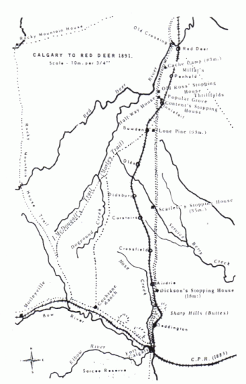
dramatic turn when the Calgary and Edmonton Railway was constructed in
1890-91. Although the overall route of the railway was to follow the
general C & E Trail corridor, the railway
decided on its own route to reduce the grade of the railway or to
accommodate their preferred locations for communities. North of Poplar Grove
(renamed Innisfail) to south Red Deer, the railway was built a couple of
miles east of the C & E Trail.
The settlement at Red Deer Crossing generally expected that the railway would cross the river
there. In fact, a townsite had been laid out in anticipation of the
railway going through the community.
However, as a result of a deal between the Calgary and Edmonton Railway
and landowner Rev. Leonard Gaetz,
the Red Deer townsite and the railway crossing of the river was located a
few kilometres downstream, resulting in the Crossing settlement no
longer being viable and most of the settlers ultimately relocating to the
new townsite.
Once the rail line was completed to South Edmonton in 1891, travel time between
the territory's two largest centres was reduced to 12 hours by train from 4 days by stagecoach.
The new railway obtained the mail contract
marking the end of the Calgary-Edmonton Trail stagecoach service.
During the 1890s, a new gravel road was built linking the communities
that the railway went through, displacing the C & E Trail as the
primary transportation route. The new road was
eventually paved to became Highway 1 in the 1930s. It was renamed Highway 2 when the
east-west
Trans Canada Highway was conceived in 1945.
It was later renamed Highway 2A when a newer four lane expressway was built in the late
1950s to early 1960s.
The newer Highway 2 was built over some segments of the old C & E Trail.
Other segments of the original Calgary & Edmonton Trail still exist as
country roads.
An ancient natural corridor has evolved to become one the most dynamic
economic regions in North America.
Photo descriptions and credits:
Header: Stagecoach along the Calgary and Edmonton Trail (Glenbow
Archives, date unknown);
Ice-free corridor map (source unknown);
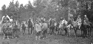
Cree and Metis at Antler Hill near Innisfail 1890 (Glenbow Archives
NA-1709-43);
Cree encampment near Innisfail 1898 (via Michael Dawe);
Fort Calgary 1878 (Glenbow Archives);
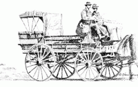
Illustration of Calgary Edmonton Trail stagecoach
(The Little Village That Grew: A History of North
Red Deer by Red Deer & District Museum Society 1987);
Red Deer Crossing settlement west of current city ca 1887 (Red Deer
Archives);
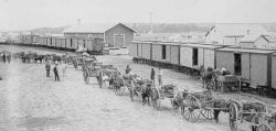
Freighters loading wagons at Calgary for trip to Edmonton 1988
(Glenbow Archives NA-3489-42);
Stagecoach along the Calgary and Edmonton Trail (Glenbow
Archives, date unknown);
Illustrative Map of Calgary Edmonton Trail and Calgary & Edmonton
Railway, Calgary to Red Deer portion
(Proud Beginnings: A Pictorial History of Red Deer
by Georgean C. Parker published by Red Deer & District
Museum Society 1981 - map courtesy Red Deer Archives
from Frontier Book No. 29);
'The Spruces' stopping house between Innisfail and Penhold at
Innisfail Historical Village (Paul Pettypiece 2006);
Calgary & Edmonton Trail stagecoach at Barnett's stopping house near
Lacombe 1880s (Glenbow Archives);
Reconstructed Fort Normandeau at Red Deer Crossing (Paul Pettypiece
2006);
Illustration of Fort Normandeau (source unknown);
Illustrative Map of Calgary Edmonton Trail and Calgary & Edmonton
Railway
(Historic Trails Alberta by Mark Anderako 1985,
Lone Pine Publishing Edmonton with permission)
|